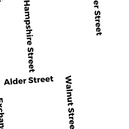
457-461 HAMPSHIRE ST
Owner Information
SILFA ELIEZER
54 INDIAN RIDGE ROAD
HAMPSTEAD, NH 03826


Property Details
457-461 HAMPSHIRE ST is classified as a Mixed Use of commercial and residential, Primarily Residential (Stores/apt com).
The primary structure on this property was built in 1910. There are 9,758ft2 of built area within this property. There is 7,359ft2 of residential/living space within this property.
457-461 HAMPSHIRE ST is valued at $578,800. The land is valued at $80,500 and the structures are valued at $485,400. There is an additional valuation of $12,900 on this property.
This property is in Zone R-. Confirm with local Zoning Board authorities to ensure there are no overlays or other easements on this property.
The most recent deed for 457-461 HAMPSHIRE ST is recorded at the local registrar in Book 16143, Page 322. 457-461 HAMPSHIRE ST was last sold on Friday, January 3, 2020 for $750,000.
Assessment data from fiscal year 2022.
Flood Data
According to the FEMA National Flood Hazard Layer, this property does not appear to be in a flood zone. It may also be in an area not yet reviewed. Nonetheless, confirm this information prior to taking any action.
To view the flood hazards around this property, create a FEMA "Firmette" Map of the area around 457-461 HAMPSHIRE ST.
Broadband Internet Providers
| Provider | Type | Bandwidth (mbps) | |
|---|---|---|---|
| HughesNet | Satellite | 25 | 3 |
| VSAT Systems, LLC. | Satellite | 2 | 1 |
| Verizon New England Inc. | Fiber | 940 | 880 |
| Verizon New England Inc. | DSL | 7 | 0 |
| Viasat Inc | Satellite | 100 | 3 |
| Crown Castle Fiber | Fiber | 0 | 0 |
| GCI Communication Corp. | Satellite | 0 | 0 |
| Comcast | Cable | 1000 | 35 |
Broadband service provider data from December 2020.
Adjacent Properties
- 156 - 158 WALNUT ST
Three-Family Residential owned by AYBAR ROSANNY - 152 - 154 WALNUT ST
Three-Family Residential owned by PROGRESSO LLC - 451 HAMPSHIRE ST
Condo owned by NUNEZ MONICA - 453 HAMPSHIRE ST
Condo owned by INIRIO GUILLERMO A - 455 HAMPSHIRE ST
Condo owned by VASQUEZ-COLON SENOBIA - 455 HAMPSHIRE ST
Other, Open Space owned by TREMPE NEREYDA TRUSTEE - 160 WALNUT ST
Two-Family Residential owned by TEJADA LESLIE